
The Chippewa Moraine Chapter officially formed in 1988, and we sponsor hikes, work outings, and presentations on glacial geology. We maintain a close relationship with the Chippewa Moraine Ice Age Reserve, where many events take place, such as the annual Parade of Colors hike.
Note: For information on the Chippewa Moraine Ice Age Reserve’s Obey Interpretive Center, please contact the center directly:
Phone: (715) 967-2800
Hours: Wednesday through Sunday, 9:00 a.m. – 3:00 p.m.
Connect With Us
Our chapter website features a wealth of information, including news items, information for hikers (including segment maps), and information for members and volunteers. There is also information about the trail-related merchandise that we sell at the Obey Interpretive Center.
We publish an email newsletter regularly, which includes short announcements, event updates, and trail condition reports.
Chip Off the Old Moraine Hiking Award Program
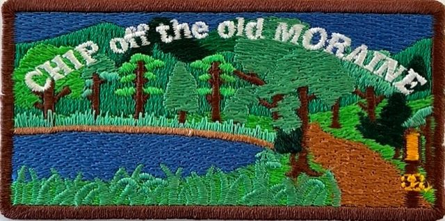
Hike Chippewa County’s Ice Age Trail segments and get an attractive patch and certificate.
Download the following resources:
- The Hiking Log with all the details.
- A list of Lodging Options In and Around Cornell — an Ice Age Trail Community.
- A list of Cornell’s Dining Options.
Chapter Meetings
We meet at the Chippewa Falls Public Library in March, May, September, and November on the third Monday of the month at 6:30 p.m. We also hold a July meeting and picnic at the Interpretive Center.
Contact us
For more information on chapter activities and/or hiking the Ice Age Trail in this region, contact our volunteer chapter coordinator:
Vicki Christianson
317 Woodside Dr.
Cornell, WI 54732
Email: chippewamorainechapter@iceagetrail.org